
A shared experience among many Novo Vizcayanos is having their province, Nueva Vizcaya, mistaken for Nueva Ecija.
While neighbors, the two provinces have distinct topography. Ecija is composed of mostly plains and marshes especially on its southwestern side that borders Pampanga, while Vizcaya's 80% forest land is spread out across its 15 municipalities.
Nueva Vizcaya is land-locked, surrounded by mountain ranges on all sides— Caraballo to the south, Sierra Madre to the east, and Cordillera to the west. This makes it ideal for nature-filled adventures like mountaineering, hiking, running, and mountain biking. Hidden within its vast forest land are some of the most idyllic trails on this side of Luzon, including the route to Mt. Pulag, the country’s third highest peak.
The province’s numerous trails introduce travelers to the quiet beauty and natural diversity of the place. Its natural features include 360-degree mountain views, multi-tiered falls, complex cave systems, picturesque "sea of clouds," pine-studded camping grounds, and protected parks and watersheds. All these make Nueva Vizcaya arguably one of the greenest in the country.
From Manila, getting there takes around 6 to 8 hours by car or bus. The weather is dry from October to April and alternately sunny and rainy from May to November. When planning a visit here, it’s best to contact the municipality’s local tourism office which can provide tours or link guests to accredited guides.
Sifting through recommendations from seasoned mountaineers and locals, here are seven memorable trails in Nueva Vizcaya that not only distinctly differentiates it from its southern neighbor but will make any visitor here remember its name.
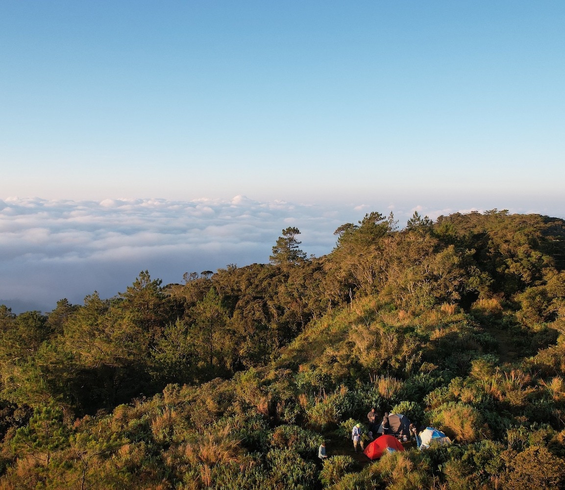
Mt. Pulag, Ambaguio

Mt. Pulag National Park is one of the best trails in Nueva Vizcaya, says Raymund Zamora who has been scaling the mountains of the province for the past 22 years and now tailors hiking packages for beginners and seasoned hikers via his tour services, Lagalag Nviz Ifugao.
Mt. Pulag is bordered by the provinces of Nueva Vizcaya, Ifugao, and Benguet, thus offering several entries and exits with different difficulty levels. Hard-core mountaineers often prefer the Nueva Vizcaya route via the municipality of Ambaguio, where it takes three days to reach the summit. At 2,922 meters above sea level, it is chilly all year round with temperatures dropping below zero from December to February.
The path going here is alternately smooth, steep, slippery, and rocky, offering changing hues of greens depending on the forest covers that one passes through. A portion can be covered in pine trees veiled in thick fog and then transition to a damp mossy forest filled with wild ferns and lichen-camouflaged trees. Once hiker reach Camp 2, the paths begin to open to vast grasslands as far as the eyes can see.
At the summit, hikers are rewarded with dramatic sunrises, sea of clouds, and views of the provinces as far as La Union and Pangasinan, including the West Philippine Sea.
Mt. Palali, Quezon

“May mga obstacles siya,” notes Zamora, who says this is what makes Mt. Palali one of his top three trails in Nueva Vizcaya.
The mountain has four entry points, one of which is the province’s capital of Bayombong, but most hikers prefer to take the Brgy. Maddiangat jump-off point in the municipality of Quezon. It’s hard to get lost on Mt. Palali as it offers a straightforward trail, says Zamora, but be sure to have your wits about you because the terrain is ever-changing, offering all sorts of "obstacles." It can be a smooth walk one minute then a steep and muddy one the next. Part of the trail even requires “4x4” style climbing where the hiker must crouch on all fours grabbing on to something stable to advance to the next terrain. A highlight is squeezing oneself between two huge rock boulders just to get to the other side.
Standing at 1,715 meters above sea level, it takes 6 to 8 hours to reach the summit, which is mostly forest strewn with preserved flora like pitcher plants and various creepers. Many climbers skip the summit and aim for Camp 2 instead where the popular “Haring Bato” marks the halfway point of the trail. Atop Haring Bato, one gets sweeping views of Nueva Vizcaya, Magat River, and other major mountains, including Mt. Ugo and the Cordillera ranges. From Camp 2, hikers take a side trip to Mapalyao falls for a much-deserved dip in its cold pool.
Mt. Ugo, Kayapa
Mt. Ugo trail in the municipality of Kayapa is a favorite among beginner to intermediate hikers because of its organized trails and breathtaking views. Bound by Benguet, it shares the same topography as the Cordilleras compared to the other municipalities of Nueva Vizcaya. Trails here are highlighted by pine trees, mossy forests, vegetable plantations, highland villages, and a sea of clouds.
There are three entry points to the trail, the most popular of which is in Brgy. Ansisip, Kayapa. From here, it takes a day’s walk to reach the summit.
For day hikes, guests can take the three-hour jeepney ride from Brgy. Pampang, get down in Sitio Domolpos in Itogon, Benguet and walk the rest of trail to reach the summit in 2 to 3 hours. This route gives them enough time to set up tents before sunset and enjoy the rest of the evening socializing.
While day hikes are possible, Zamora recommends an overnight stay to catch the stunning sunrise the next day. With an elevation of 2,220 meters above sea level and a trail length covering 33 kms, Mt. Ugo has a class difficulty of 5/9. Mt. Ugo is open for daytime hikes, overnight camping, and mountain biking. Book in advance because only 50 visitors are allowed per day. Contact the local tourism at tourism.kayapa@gmail.com or at 09106181910.
Machalet Falls, Kasibu
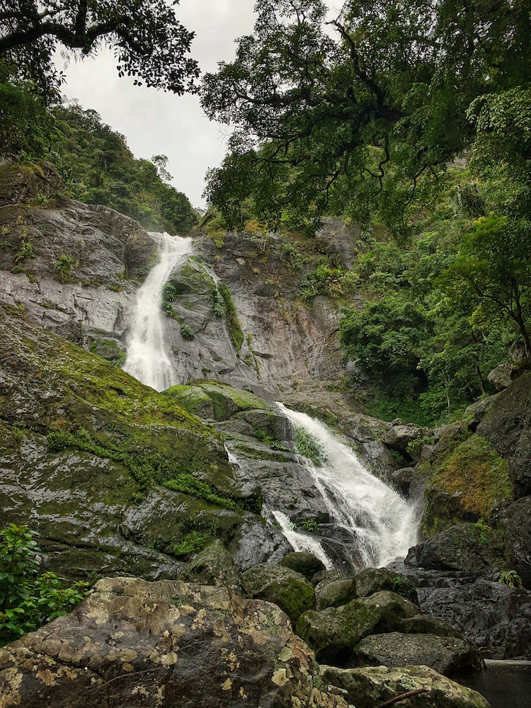
You will never experience a quieter, more pristine town in Vizcaya than Kasibu. This town is studded with cave systems, including the fifth longest in the country, the 4.2-km Capisaan Cave. Gaining as much attraction as the Capisaan Cave are the municipality’s many hidden waterfalls. Composed of different drops and pool visibilities, they are waiting to be discovered like lost gems in a forest.
Opened to the public just before the pandemic is Machalet Falls, one of tallest at seven drops. Three drops are accessible to guests, thanks to the paved paths and cemented stairsteps that safely get them from one Instagram-able fall to another.
From Kasibu town proper, it takes two hours to get to Brgy. Biyoy where Machelet is located. The road going there is mostly cemented but the last 8 kilometers are unpaved, creating deep, slippery, and muddy pockets when it rains. Only 4x4 vehicles and motorbikes are used here, but even with an all-terrain vehicle, guests are encouraged to just hike the rest of the rough road because once it rains, the mud can be mightier than Machelet and can get wheels stuck for hours.
The short hike is an opportunity for guests to enjoy the thick foliage that wraps around the rock formations of the falls, views of irregularly shaped mountains nearby, and a unique vantage point from which to photograph the falls. To visit, contact Kasibu Tourism at kasibutourism@yahoo.com or through FB at /kasibutourism.
Lake Buaca, Kayapa

Lake Buaca is an easy and relaxing sidetrip for visitors to the town of Kayapa. Just five kilometers roundtrip from its starting point along the Highway in Brgy. Castillo, one can reach the summit in an hour or two. It is situated 1,583 meters above sea level and is considered part of Kayapa’s Municipal Park. The path is well paved with signs to guide hikers at key points. It combines flat and uphill terrain with many areas shaded by Benguet pine trees, Philippine oaks, and giant ferns called tibanglan.

Once the trail begins to ascend, hikers can get snapshot worthy views of the Cordillera mountain ranges and vegetable plantations below. Intermittent Wi-Fi in the area even allows one to post photos on social media "atm" while hiking. A good way to enjoy this easy hike is a picnic by the lake. Seek the permission of the local tourism a day ahead as the trail is not yet fully open to visitors. Contact them at tourism.kayapa@gmail.com or at 0910-6181910.
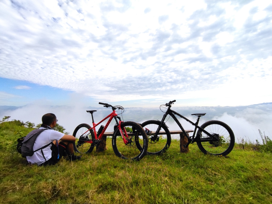
Tawi-Tawi, Bagabag

The hills of Sitio Tawi-tawi promise a long, exciting but friendly trail for bikers and runners, starting from Brgy. Beretbet in Bagabag and exiting in Brgy. Maddiangat in Quezon. Ian Acierto, one of the founding members of the newly formed Vizcaya Runnrs, has tested this trail several times and gives it a 10/10 rating. From end to end, runners and bikers can cover more than 50 km of rough roads with exciting ascents and descents, giving just the right amount of adrenaline for advanced marathoners like Ian.
The trail offers endless views of rolling hills on both sides occasionally punctuated with rice fields, pockets of pineapple plantations, thick foliage, and animal pastures. Tawi-tawi is a perfect place to test your tires if you’re looking for trails accessible from Nueva Vizcaya’s capital of Bayombong. Simply connect with Vizcaya Runnrs.
Mt. Singian, Solano
Hikers, bikers, and runners from the nearby municipalities of Bagabag, Solano, and Bayombong attest to the beauty of Mt. Singian in Brgy. Aggub, Solano. For them, this is the nearest trail that features a great seven-minute downhill ride enough to get them to come back again and again.
For hikers and runners, the trek up the summit covers around 13 kms. It takes just around two hours or less to navigate the mountain roundtrip making it ideal for beginners. The terrain is mostly uphill and, once at the top, one will be greeted by a heavenly sea of clouds and grand views of the towns below. Connect with Vizcaya Runnrs to find out more about Mt. Singian.